If you haven't done so, I suggest you read the introduction and the spoiler alert in Four Hikes in High Mountains before reading further.
I accessed the Chokramudi Peak trail from the new and modern Hwy 85 (Google Maps), near the Lockhart Gap overlook. The car pulled off to the roadside and the Forest Department office was a few steps up. My guide, the handsome Mr. Hadson, went in and got the permit, a couple of water bottles included. The FD assigned their own guide, a young, lean, soft-spoken guy with the pleasing and reassuring name, Sreekrishnan. With Hadson in the front and Sreekrishnan guarding the back, I felt up to the challenge, whatever it may be. It was just after 10 am, partly cloudy, with a light wind, and a pleasant 65 degrees.
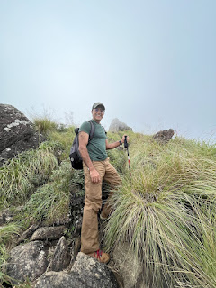
The trail starts through a stand of eucalyptus trees and turns into a rock-strewn grassy expanse with a valley of hills blanketed by tea plantations below to the left. The brisk wind whipped the mist over the hills, clearing momentarily offering fleeting views of the mountains in the distance and the uphill climb ahead. The beginning one-third is fairly steep, boulder-filled, and occasionally slippery. About fifteen minutes in, I began panting heavily. Hadson advised me to stop and take slow deep breaths. This helped immensely. Meanwhile, much to my chagrin, Hadson and Sreekrishnan appeared to be handling the hike like a walk in the park. I didn’t hear a whiff of strained breath coming from them. I chalked it up to their acclimatization to heights, which Hadson politely did not challenge. As for the views, I will let the pictures I have included here speak and summarize what I saw and experienced at the end.
“Are we there yet?” I yelled after a stretch of continuous climb.

“We are a third of the way!” Hadson replied with a reality check.
Further uphill we hit an extended rocky area where I crouched almost to a crawl to keep my center of gravity low. Turning around and looking back gave me shivers thinking how am I ever going to get back down. The way back looked like a vertical drop.

The trail leveled out a bit and suddenly out of the fog appeared a dense stand of trees and shrubs, which Hadson explained is a Shola forest unique to this environment. Even if short, walking through it enveloped on all sides by mist and thick vegetation added to the exhilaration.
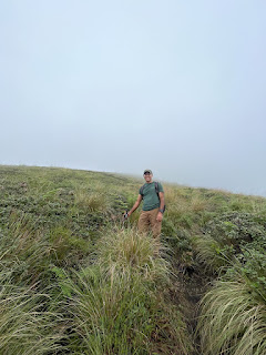
Past the Shola stand, more climbing through grassland covered with all manner of wildflowers. I checked in with Hadson who said we were two-thirds to the peak. As we got higher, the trail narrowed to a ridge—30 to 50 feet wide, occasionally even less. On either side are steep drops, how far down I couldn't tell because of the clouds shrouding the mountain below the rim. The clouds would clear for a brief moment, and I could see Devikulam Valley down below carpeted by tea plantations, worker hamlets, and the ribbon-like Hwy 85.


After more climbing and as lichen-splashed rocks protruding from the ground grew larger, Hadson pointed to the distance: “That’s the peak, that’s where we are headed.” The fog rolled over the narrow ridge providing just enough visibility to bring the entire peak towering through the clouds into view. Amidst the gigantic rocks, blowing mist, lush grass, and wildflowers, it was a breathtaking sight. We carefully hiked down a neck where the path was just about five feet wide with rocks to the right and a cliff face to nowhere to the left. Climbing up from the neck, we reached the peak, a rock top with patches of grass and shallow ditches that held puddles of water from the rains earlier. The elation of standing there looking into the distance, feeling the wind blow, viewing the clouds roll down below, can only be felt, not described. My watch clocked the ascent at 1 hour and 37 minutes.


After taking the views from different vantage points, I sat down to snack. That’s when awe gave way to annoyance—flies. With these unexpected intruders swarming around, it became impossible to sit or lie down, as Hadson tried to do. I took one final look around and we headed back.
The leisurely but still risky descent gave a different perspective of the varied flora along the trail: vivid wildflowers amidst lush, untamed grass, thorny bushes hiding their sting under the cover of tempting ruby red berries, lone rhododendrons rising from between rocks, striking a majestic pose against the blowing fog that merged with the clouds and the sky beyond into one grey blanket.


The fog had grown noticeably thicker reducing visibility to perhaps 50 feet. The trail leveled off and we went back through the Shola forest. Emerging out into the enveloping fog, I looked up and froze: up on a mount ahead to the right was the ethereal silhouette of a lone Nilgiri Thar, the famed endangered mountain goat endemic to this region. He stood staring back at us from the commanding height. We tiptoed closer to get a better view and pictures. And then just as suddenly he had appeared, he vanished into the fog. It was entirely magical.

Back on the trail and down over the rocky area and grassland, the downhill hike was thrilling, not as dreadful as I had feared. The steep descent, low visibility, and briskly blowing fog added to the adventure. And just like that, we were walking through the eucalyptus stand and back at the trailhead near the FD office.
It was an immersive, exhilarating, and in the true sense of the word, awesome, hike. By far the best hike I have been on. In all it took 3 hours 23 minutes, covering 3.37 miles, and an elevation gain of 1,728 feet. In the entire hike, I saw only a single other hiker, a European and his guide. I have posted a string of video clips on my YouTube channel, in case you wish to take a peek. No requirement to like, share, or subscribe.
If you came directly to this hike description, visit my introduction. Otherwise, here are the rest of the hikes:
Eravikulam National Park & Thoovanam Waterfall
Meesapulimala
Letchmi Hills
Happy Hiking!